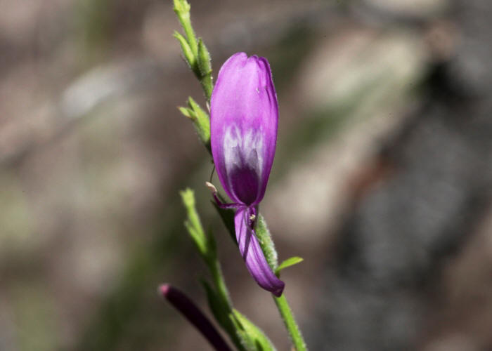
Hypoestes floribunda var. yorkensis
.JPG)
.JPG)
.JPG)
.JPG)

.JPG)
1.JPG)
1.JPG)
.JPG)
.JPG)
.JPG)
.JPG)
|
Hypoestes floribunda var. yorkensis |
Hypoestes floribunda var. yorkensis |
|
.JPG) |
.JPG) |
|
| Description:Flower | Description:Flower | |
| Location:Chong Swamp, Oyala Thumotang National Park, Coen, North Queensland | Location:Chong Swamp, Oyala Thumotang National Park, Coen, North Queensland | |
| GPS coordinates:13˚36.769S,142˚34.946E | GPS coordinates:13˚36.769S,142˚34.946E | |
| Date of photo:20 July 2010 | Date of photo:20 July 2010 | |
| Field No.:U391 | Field No.:U391 | |
|
Hypoestes floribunda var. yorkensis |
Hypoestes floribunda var. yorkensis |
|
.JPG) |
.JPG) |
|
| Description:Flower | Description:Flower | |
| Location:Chong Swamp, Oyala Thumotang National Park, Coen, North Queensland | Location:Chong Swamp, Oyala Thumotang National Park, Coen, North Queensland | |
| GPS coordinates:13˚36.769S,142˚34.946E | GPS coordinates:13˚36.769S,142˚34.946E | |
| Date of photo:20 July 2010 | Date of photo:20 July 2010 | |
| Field No.:U391 | Field No.:U391 | |
|
|
||
| Hypoestes floribunda R.Br. var. floribunda | ||
|
These plants are from Magnetic Island. |
||
| Hypoestes floribunda var. floribunda | Hypoestes floribunda var. floribunda | |
 |
.JPG) |
|
| Description:Flower | Description:Flower | |
| Location:Balding Bay, Magnetic Island, North Queensland | Location:Balding Bay, Magnetic Island, North Queensland | |
| GPS coordinates:19˚06.676S,146˚52.102E | GPS coordinates:19˚06.676S,146˚52.102E | |
| Date of photo:19 April 2014 | Date of photo:19 April 2014 | |
| Field No.:2480 | Field No.:2480 | |
| Hypoestes floribunda var. floribunda | Hypoestes floribunda var. floribunda | |
1.JPG) |
1.JPG) |
|
| Description:Plant in habitat | Description:Leaves | |
| Location:Balding Bay, Magnetic Island, North Queensland | Location:Balding Bay, Magnetic Island, North Queensland | |
| GPS coordinates:19˚06.676S,146˚52.102E | GPS coordinates:19˚06.676S,146˚52.102E | |
| Date of photo:19 April 2014 | Date of photo:19 April 2014 | |
| Field No.:2480 | Field No.:2480 | |
| Hypoestes floribunda var. varia R.M.Barker | ||
| These plants are from Kakadu National Park. | ||
| Hypoestes floribunda var. varia | Hypoestes floribunda var. varia | |
.JPG) |
.JPG) |
|
| Description:Flower | Description:Flower | |
| Location:Nourlangie Rock, Kakadu, Northern Territory | Location:Nourlangie Rock, Kakadu, Northern Territory | |
| GPS coordinates:12˚51.913S,132˚48.913E | GPS coordinates:12˚51.913S,132˚48.913E | |
| Date of photo:7 June 2015 | Date of photo:7 June 2015 | |
| Field No.:3196 | Field No.:3196 | |
| Hypoestes floribunda var. varia | Hypoestes floribunda var. varia | |
.JPG) |
.JPG) |
|
| Description:Flower | Description:Plant in habitat | |
| Location:Nourlangie Rock, Kakadu, Northern Territory | Location:Nourlangie Rock, Kakadu, Northern Territory | |
| GPS coordinates:12˚51.913S,132˚48.913E | GPS coordinates:12˚51.913S,132˚48.913E | |
| Date of photo:7 June 2015 | Date of photo:7 June 2015 | |
| Field No.:3196 | Field No.:3196 | |
|
Hypoestes floribunda
var.
distans
|
||
| These plants are from Mitchell Falls in the Kimberley region of Western Australia. This variety has white flowers with a mauve - pink blush and is endemic to the northern Kimberley region. | ||
| Hypoestes floribunda var. distans | Hypoestes floribunda var. distans | |
|
|
|
|
| Description:Flower - side view | Description:Flower showing blush | |
| Location:Mitchell Falls National Park, Kimberleys, Western Australia | Location:Mitchell Falls National Park, Kimberleys, Western Australia | |
| GPS coordinates:14˚49.3032S,125˚43.0776E | GPS coordinates:14˚49.3032S,125˚43.0776E | |
| Date of photo:17 July 2016 | Date of photo:17 July 2016 | |
| Field No.:5078 | Field No.:5078 | |
| Hypoestes floribunda var. distans | Hypoestes floribunda var. distans | |
|
|
|
|
| Description:Plant | Description:Plant showing spindly habit | |
| Location:Mitchell Falls National Park, Kimberleys, Western Australia | Location:Mitchell Falls National Park, Kimberleys, Western Australia | |
| GPS coordinates:14˚49.3032S,125˚43.0776E | GPS coordinates:14˚49.3032S,125˚43.0776E | |
| Date of photo:17 July 2016 | Date of photo:17 July 2016 | |
| Field No.:5078 | Field No.:5078 | |
| Hypoestes floribunda var. distans | Hypoestes floribunda var. distans | |
|
|
|
|
| Description:Flower - side view | Description:Flower | |
| Location:Mitchell Falls National Park, Kimberleys, Western Australia | Location:Mitchell Falls National Park, Kimberleys, Western Australia | |
| GPS coordinates:14˚49.3032S,125˚43.0776E | GPS coordinates:14˚49.3032S,125˚43.0776E | |
| Date of photo:17 July 2016 | Date of photo:17 July 2016 | |
| Field No.:5078 | Field No.:5078 | |
References (accessed 19 September 2016):
http://sgaptownsville.org.au/Hypoestes-floribunda.html
Barker, R.M., (1986) A taxonomic revision of Australian Acanthaceae. Journal of the Adelaide Botanic Gardens 9: 198-225
https://florabase.dpaw.wa.gov.au/browse/profile/13957
Image use policy 
This work is licensed under a
Creative Commons Attribution-Noncommercial 2.5 Australia License.
Page created 28 December 2012
Page edited 15 January 2017
© Roger Fryer and Jill Newland 2012 - 2017