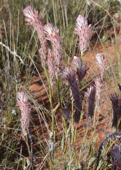
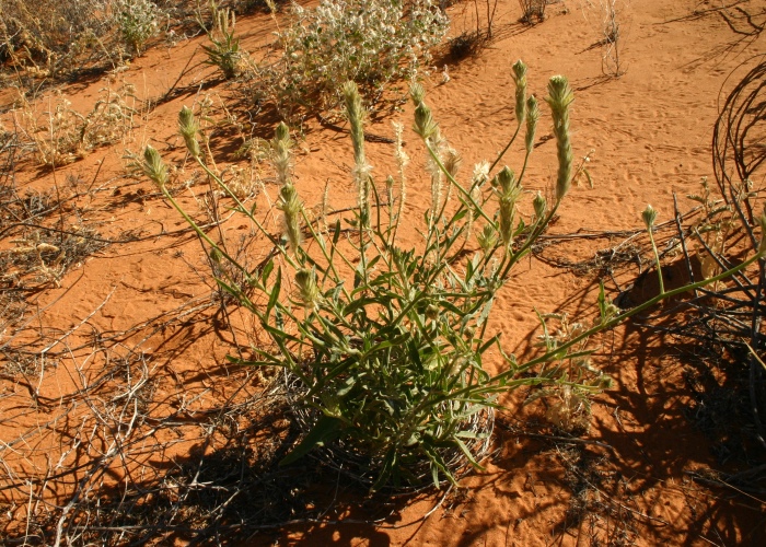
| Ptilotus polystachyus |
Ptilotus polystachyus |
 |
.JPG) |
| Description:Plant (pink form) |
Description:Plant (green form) |
| Location: Highway 8, East of Alice Springs, Northern Territory |
Location:Highway 8,
East of Alice Springs, Northern Territory |
| GPS
coordinates:N/A |
GPS
coordinates:N/A |
| Date of photo:2 October 2010 |
Date of photo:2 October 2010 |
| Field No.:U548 |
Field No.:U548 |
| |
|
| Ptilotus polystachyus |
Ptilotus polystachyus |
.JPG) |
.JPG) |
| Description:Pink
flowers |
Description:Flowers |
| Location:Urandangie
to Dajarra, North West Queensland |
Location:Highway 8, E of Alice Springs, Northern Territory |
| GPS
coordinates:N/A |
GPS
coordinates:N/A |
|
Date of photo:27 June 2009 |
Date of photo:2 October 2010 |
|
Field No.:U547 |
Field No.:U548 |
| |
|
| Ptilotus polystachyus |
Ptilotus polystachyus |
%20-%20Copy.jpg) |
.jpg) |
| Description:Plant
in habitat |
Description:Plant
in habitat |
|
Location:Birdsville Track, South West Queensland |
Location:Birdsville
Track, South West Queensland |
|
GPS coordinates:26˚24.995S,139˚31.444E |
GPS coordinates:26˚24.995S,139˚31.444E |
| Date of photo:6
August 2012 |
Date of photo:6
August 2012 |
| Field No.:1133 |
Field No.:1124 |
| |
|
| Ptilotus polystachyus |
Ptilotus polystachyus |
 |
.JPG) |
| Description:Plant
in habitat |
Description:Plant
showing sprawling habit |
| Location:Sand Dune, Diamantina National Park, South West Queensland |
Location:Sand Dune, Diamantina National Park, South West Queensland |
| GPS
coordinates:N/A |
GPS
coordinates:N/A |
| Date of photo:16
June 2007 |
Date of photo:24 June 2009 |
| Field No.:U549 |
Field No.:U549 |
| |
|
| Ptilotus polystachyus |
Ptilotus polystachyus |
.JPG) |
.JPG) |
| Description:Flowers |
Description:Plant
in habitat |
| Location:Joonjoo
Botanical Trail, Derby, Western Australia |
Location:Joonjoo
Botanical Trai, Derby, Western Australia |
|
GPS coordinates:17˚20.7870S,123˚39.8840E |
GPS coordinates:17˚20.7870S,123˚39.8840E |
| Date of photo:22
June 2017 |
Date of photo:22
June 2017 |
| Field No.:6164 |
Field No.:6164 |
| |
|
| Ptilotus polystachyus |
Ptilotus polystachyus |
.JPG) |
.JPG) |
| Description:Leaf |
Description:Leaf -
underside |
| Location:Joonjoo
Botanical Trai, Derby, Western Australia |
Location:Joonjoo
Botanical Trai, Derby, Western Australia |
|
GPS coordinates:17˚20.7870S,123˚39.8840E |
GPS coordinates:17˚20.7870S,123˚39.8840E |
| Date of photo:22
June 2017 |
Date of photo:22
June 2017 |
| Field No.:6164 |
Field No.:6164 |
| |
|
| |
|
| |
|

.JPG)
.JPG)
.JPG)
%20-%20Copy.jpg)
.jpg)

.JPG)
