|
|
Heliotropium tabuliplagae |
Heliotropium
tabuliplagae |
| |
|
.JPG) |
.JPG) |
|
|
Description: Flower |
Description:
A small straggling flowering plant |
| |
|
Location:
Mowbray Falls, Mt Misery, North Queensland |
Location:
Mowbray Falls, Mt Misery, North Queensland |
| |
|
GPS coordinates:17˚31.320S 145˚14.522E |
GPS coordinates:17˚31.320S 145˚14.522E |
|
|
Date:30
March 2014 |
Date:30
March 2014 |
| |
|
Field
No.:2477 |
Field
No.:2477 |
| |
|
|
|
| |
|
Heliotropium
tabuliplagae |
Heliotropium
tabuliplagae |
| |
|
.JPG) |
.JPG) |
| |
|
Description: Leaves |
Description: Plant |
| |
|
Location:
Mowbray Falls, Mt Misery, North Queensland |
Location:
Mowbray Falls, Mt Misery, North Queensland |
| |
|
GPS coordinates:17˚31.320S 145˚14.522E |
GPS coordinates:17˚31.6668S 145˚14.8170E |
| |
|
Date:30
March 2014 |
Date:24
January 2016 |
| |
|
Field
No.:2477 |
Field
No.:3861 |
| |
|
|
|
| |
|
Heliotropium tabuliplagae |
Heliotropium
tabuliplagae |
| |
|
.JPG) |
.JPG) |
| |
|
Description: Flower |
Description:
A small straggling flowering plant |
| |
|
Location:
Burke Development Rd, Petford, North Queensland |
Location:
Burke Development Rd, Petford, North Queensland |
| |
|
GPS coordinates:17º14.371S,
145º00.251E |
GPS coordinates:17º14.371S,
145º00.251E |
| |
|
Date:1
February 2015 |
Date:1 February 2015 |
| |
|
Field
No.:2985 |
Field
No.:2985 |
| |
|
|
|
| |
|
Heliotropium tabuliplagae |
Heliotropium
tabuliplagae |
| |
|
.JPG) |
.JPG) |
| |
|
Description: Leaves |
Description: Plants in-situ |
| |
|
Location:
Burke Development Rd, Petford, North Queensland |
Location:
Burke Development Rd, Petford, North Queensland |
| |
|
GPS coordinates:17º14.371S,
145º00.251E |
GPS coordinates:17º14.371S,
145º00.251E |
| |
|
Date:1
February 2015 |
Date:1
February 2015 |
| |
|
Field
No.:2985 |
Field
No.:2985 |
| |
|
|
|
| |
|
Heliotropium tabuliplagae |
Heliotropium
tabuliplagae |
| |
|
.JPG) |
.JPG) |
| |
|
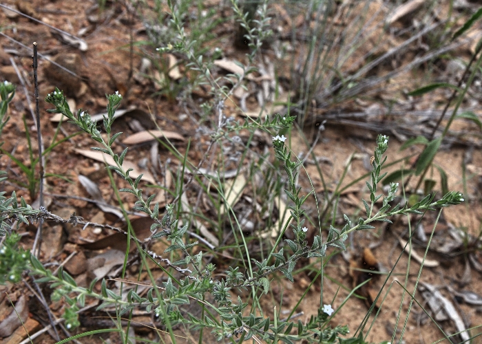
Description: Plant in habitat |
Description: Plant |
| |
|
Location:
Mowbray Falls, Mt Misery, North Queensland |
Location:
Mowbray Falls, Mt Misery, North Queensland |
| |
|
GPS coordinates:17˚31.6668S 145˚14.8170E |
GPS coordinates:17˚31.6668S 145˚14.8170E |
| |
|
Date:24
January 2016 |
Date:24
January 2016 |
| |
|
Field
No.:3861 |
Field
No.:3861 |
| |
|
|
|
| |
|
Heliotropium tabuliplagae |
Heliotropium
tabuliplagae |
| |
|
.JPG) |
 |
| |
|
Description: Flower |
Description: Plant in habitat |
| |
|
Location:
Road to Mount Mulligan, North Queensland |
Location:
Road to Mount Mulligan, North Queensland |
| |
|
GPS coordinates:16˚58.5138S 145˚01.1346E |
GPS coordinates:16˚58.5138S 145˚01.1346E |
| |
|
Date:21 February 2016 |
Date:21
February 2016 |
| |
|
Field
No.:3895 |
Field
No.:3895 |
| |
|
|
|
| |
|
Heliotropium tabuliplagae |
Heliotropium
tabuliplagae |
| |
|
.JPG) |
.JPG) |
| |
|
Description: Flower |
Description: Flower - side view and leaves |
| |
|
Location:
Spinifex Callpoint 3, Ewan, North Queensland |
Location:
Spinifex Callpoint 3, Ewan, North Queensland |
| |
|
GPS coordinates:19°09.1362S,
145°55.1658E |
GPS coordinates:19°09.1362S,
145°55.1658E |
| |
|
Date:21
April 2017 |
Date:21
April 2017 |
| |
|
Field
No.:6052 |
Field
No.:6052 |
| |
|
|
|
.JPG)
.JPG)
.JPG)
.JPG)
.JPG)
.JPG)
.JPG)
.JPG)
.JPG)
.JPG)
.JPG)

.JPG)
.JPG)
