1.JPG)
.JPG)
1.JPG)

33.JPG)
1.JPG)
1.JPG)
.JPG)
.JPG)
.jpg)
.jpg)
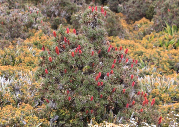
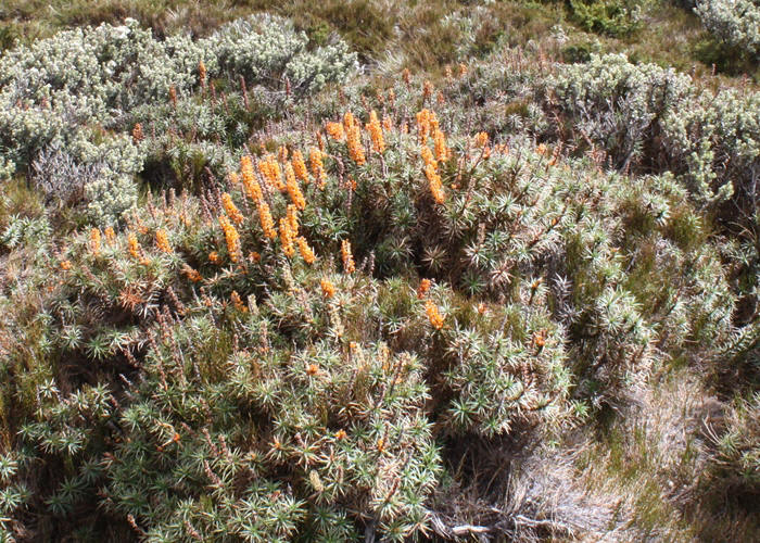
| Richea scoparia | Richea scoparia | |
 |
1.JPG) |
|
| Description:Plant | Description:Plant | |
| Location:Hartz Mountains,Tasmania | Location:Hartz Mountains,Tasmania | |
| GPS coordinates: 41˚13.6620S 146˚46.3900E | GPS coordinates: 41˚13.6620S 146˚46.3900E | |
| Date of photo:4 January 2010 | Date of photo:4 January 2010 | |
| Field No.:U570 | Field No.:U570 | |
| Richea scoparia | Richea scoparia | |
.JPG) |
1.JPG) |
|
| Description:Flower spike | Description:Flower spike - buds | |
| Location:Dove Lake Circuit,Tasmania | Location:Hartz Mountains,Tasmania | |
| GPS coordinates: 41˚39.543S 145˚57.891E | GPS coordinates: 41˚13.6620S 146˚46.3900E | |
| Date of photo:15 January 2013 | Date of photo:4 January 2010 | |
| Field No.:1918 | Field No.:U570 | |
| Richea scoparia | Richea scoparia | |
 |
33.JPG) |
|
| Description:Plant | Description:Plant in habitat | |
| Location:Ben Lomond, Tasmania | Location:Ben Lomond, Tasmania | |
| GPS coordinates: 41˚32.405S 147˚40.470E | GPS coordinates: 41˚32.405S 147˚40.470E | |
| Date of photo:20 January 2010 | Date of photo:20 January 2010 | |
| Field No.:U569 | Field No.:U569 | |
| Richea scoparia | Richea scoparia | |
1.JPG) |
1.JPG) |
|
| Description:Plant in habitat | Description:Flower spike | |
| Location:Dove Lake Circuit, Tasmania | Location:Arve Falls, Hartz Mountains,Tasmania | |
| GPS coordinates: 41˚39.543S 145˚57.891E | GPS coordinates:43˚12.544S 146˚46.234E | |
| Date of photo:15 January 2013 | Date of photo:6 January 2013 | |
| Field No.:1918 | Field No.:1822 | |
| Richea scoparia | Richea scoparia | |
.JPG) |
.JPG) |
|
| Description:Plant in habitat | Description:Plant in habitat | |
| Location:Dove Lake Circuit, Tasmania | Location:Dove Lake Circuit, Tasmania | |
| GPS coordinates: 41˚39.543S 145˚57.891E | GPS coordinates: 41˚39.543S 145˚57.891E | |
| Date of photo:15 January 2013 | Date of photo:15 January 2013 | |
| Field No.:1918 | Field No.:1918 | |
| Richea scoparia | Richea scoparia | |
|
|
.jpg) |
|
| Description:White flower | Description:Plants in habitat | |
| Location:Road to Lake Augusta,Tasmania | Location:Pine Lake,Tasmania | |
| GPS coordinates: 41˚51.566S 146˚35.211E | GPS coordinates: 41˚44.443S 146˚42.365E | |
| Date of photo:2 January 2016 | Date of photo:13 January 2013 | |
| Field No.:3735 | Field No.:1928 | |
| Richea scoparia | Richea scoparia | |
|
|
.jpg) |
|
| Description:Plants | Description:Plants in habitat | |
| Location:Road to Lake Ada,Tasmania | Location:Road to Lake Ada,Tasmania | |
| GPS coordinates: 41˚52.710S 146˚30.038E | GPS coordinates: 41˚52.710S 146˚30.038E | |
| Date of photo:2 January 2016 | Date of photo:2 January 2016 | |
| Field No.:3752 | Field No.:3752 | |
References (accessed 26 August 2017):
Menadue, Y. & Crowden, R.K., (2000) Taxonomic revision of Richea R.Br. (Epacridaceae). Australian Systematic Botany. 13(5):773-802
http://www.utas.edu.au/dicotkey/dicotkey/EPACRIDS/sRichea_scoparia.htm
Image use policy 
This work is licensed under a
Creative Commons Attribution-Noncommercial 2.5 Australia License.
Page Created 6 January 2012
Page edited 26 August 2017
© Roger Fryer and Jill Newland 2012 - 2017