.JPG)
.JPG)
.JPG)
.JPG)
.JPG)
.JPG)
.JPG)
.JPG)
.JPG)
.JPG)
.JPG)
.JPG)
.JPG)
.JPG)
.JPG)
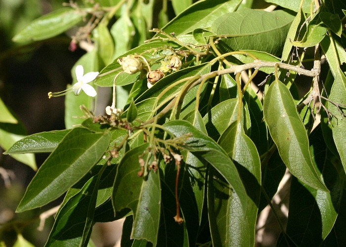
| Clerodendrum floribundum | Clerodendrum floribundum | |
|
|
|
|
| Description:Flowers and leaves | Description:Flowers and leaves | |
| Location:Irvinebank, North Queensland | Location:Irvinebank, North Queensland | |
| GPS coordinates:17°25.727S 145°12.023E | GPS coordinates:17°25.727S 145°12.023E | |
| Date of photo:10 October 2008 | Date of photo:10 October 2008 | |
| Field No.:U762 | Field No.:U762 | |
| Clerodendrum floribundum | Clerodendrum floribundum | |
|
|
|
|
| Description:Branch of shrub | Description:Flowers | |
| Location:Irvinebank, North Queensland | Location:Welford National Park, Western Queensland | |
| GPS coordinates:17°25.727S 145°12.023E | GPS coordinates:25°09.8758S 143°20.6742E | |
| Date of photo:10 October 2008 | Date of photo:11 July 2009 | |
| Field No.:U762 | Field No.:U763 | |
| Clerodendrum floribundum | Clerodendrum floribundum | |
|
|
|
|
| Description:Shrub in habitat | Description:Shrub in habitat with Calandrinia sp | |
| Location:Irvinebank, North Queensland | Location:Welford National Park, Western Queensland | |
| GPS coordinates:17°25.727S 145°12.023E | GPS coordinates:25°09.8758S 143°20.6742E | |
| Date of photo:10 October 2008 | Date of photo:11 July 2009 | |
| Field No.:U762 | Field No.:U763 | |
| Clerodendrum floribundum | Clerodendrum floribundum | |
|
|
|
|
| Description:Flowers | Description:Flower | |
| Location:Welford National Park, Western Queensland | Location:Boodjamulla National Park, Western Queensland | |
| GPS coordinates:25°09.8758S 143°20.6742E | GPS coordinates:18°42.8403S 138°28.9206E | |
| Date of photo:11 July 2009 | Date of photo:24 June 2008 | |
| Field No.:U763 | Field No.:U764 | |
| Clerodendrum floribundum | Clerodendrum floribundum | |
|
|
|
|
| Description:Leaves | Description:Early fruit | |
| Location:Boodjamulla National Park, Western Queensland | Location:Boodjamulla National Park, Western Queensland | |
| GPS coordinates:18°42.8403S 138°28.9206E | GPS coordinates:18°42.8403S 138°28.9206E | |
| Date of photo:24 June 2008 | Date of photo:24 June 2008 | |
| Field No.:U764 | Field No.:U764 | |
| Clerodendrum floribundum | Clerodendrum floribundum | |
|
|
|
|
| Description:Flowers | Description:Flower | |
| Location:Well 38, Canning Stock Route, Western Australia | Location:Well 38, Canning Stock Route, Western Australia | |
| GPS coordinates:21°58.7196S, 125°31.8600E | GPS coordinates:21°58.7196S, 125°31.8600E | |
| Date of photo:31 July 2016 | Date of photo:31 July 2016 | |
| Field No.:5244 | Field No.:5244 | |
| Clerodendrum floribundum | Clerodendrum floribundum | |
|
|
|
|
| Description:Fruit | Description:Plant in habitat | |
| Location:Well 38, Canning Stock Route, Western Australia | Location:Well 38, Canning Stock Route, Western Australia | |
| GPS coordinates:21°58.7196S, 125°31.8600E | GPS coordinates:21°58.7196S, 125°31.8600E | |
| Date of photo:31 July 2016 | Date of photo:31 July 2016 | |
| Field No.:5244 | Field No.:5244 | |
| Clerodendrum floribundum | Clerodendrum floribundum | |
|
|
|
|
| Description:Flowers | Description:Shrub in habitat | |
| Location:Wivanhoe Lookout, Mt Glorious, Queensland | Location:Wivanhoe Lookout, Mt Glorious, Queensland | |
| GPS coordinates:27°17.7948S, 152°43.7598E | GPS coordinates:27°17.7948S, 152°43.7598E | |
| Date of photo:11 November 2016 | Date of photo:11 November 2016 | |
| Field No.:5749 | Field No.:5749 | |
Image use policy 
This work is licensed under a
Creative Commons Attribution-Noncommercial 2.5 Australia License.
Page created 14 June 2016
Page edited 14 January 2017
© Roger Fryer and Jill Newland 2016