.jpg)

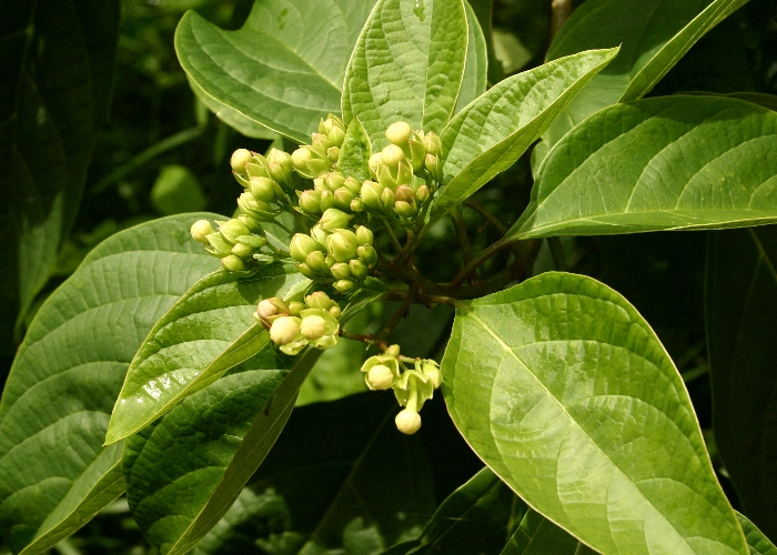
| Clerodendrum longiflorum var.glabrum | Clerodendrum longiflorum var.glabrum | |
|
|
|
|
| Description : Normal flowers and buds | Description:Flowers - side view | |
| Location:Cook Highway, Kewarra Beach, North Queensland | Location:Cook Highway, Kewarra Beach, North Queensland | |
| GPS coordinates:16°47.6784S 145°40.8534E | GPS coordinates:16°47.6784S 145°40.8534E | |
| Date of photo:1 June 2016 | Date of photo:1 June 2016 | |
| Field No.:4037 | Field No.:4037 | |
| Clerodendrum longiflorum var.glabrum | Clerodendrum longiflorum var.glabrum | |
|
|
|
|
| Description:Distorted flowers due to galls. | Description:Buds and leaves | |
| Location:Cook Highway, Kewarra Beach, North Queensland | Location:Mowbray River, Mossman, North Queensland | |
| GPS coordinates:16°47.6784S 145°40.8534E | GPS coordinates:16°33.1812S 145°28.9692E | |
| Date of photo:1 June 2016 | Date of photo:15 May 2016 | |
| Field No.:4037 | Field No.:4033 | |
| Clerodendrum longiflorum var.glabrum | Clerodendrum longiflorum var.glabrum | |
|
|
|
|
| Description:Leaf | Description:Leaf - underside | |
| Location:Smithfield Conservation Park, North Queensland | Location:Smithfield Conservation Park, North Queensland | |
| GPS coordinates:16˚48.6294S, 145°41.2554E | GPS coordinates:16˚48.6294S, 145°41.2554E | |
| Date of photo:17 June 2018 | Date of photo:17 June 2018 | |
| Field No.:6667 | Field No.:6667 | |
| Clerodendrum longiflorum var.glabrum | Clerodendrum longiflorum var.glabrum | |
|
|
|
|
| Description:Distorted flowers due to galls | Description:Beetle on flower | |
| Location:Smithfield Conservation Park, North Queensland | Location:Smithfield Conservation Park, North Queensland | |
| GPS coordinates:16˚48.6294S, 145°41.2554E | GPS coordinates:16˚48.6294S, 145°41.2554E | |
| Date of photo:17 June 2018 | Date of photo:17 June 2018 | |
| Field No.:6667 | Field No.:6667 | |
| Clerodendrum longiflorum var.glabrum | Clerodendrum longiflorum var.glabrum | |
|
|
|
|
| Description:Trunk of small tree showing bark | Description:Flowers | |
| Location:Smithfield Conservation Park, North Queensland | Location:Smithfield Conservation Park, North Queensland | |
| GPS coordinates:16˚48.6294S, 145°41.2554E | GPS coordinates:16˚48.6294S, 145°41.2554E | |
| Date of photo:17 June 2018 | Date of photo:17 June 2018 | |
| Field No.:6667 | Field No.:6667 | |
| Clerodendrum longiflorum var.glabrum | Clerodendrum longiflorum var.glabrum | |
|
|
|
|
| Description:Leaves | Description:Leaves | |
| Location:Smithfield Conservation Park, North Queensland | Location:Smithfield Conservation Park, North Queensland | |
| GGPS coordinates:16˚48.6294S, 145°41.2554E | GPS coordinates:16˚48.6294S, 145°41.2554E | |
| Date of photo:17 June 2018 | Date of photo:17 June 2018 | |
| Field No.:6667 | Field No.:6667 | |
| Clerodendrum longiflorum var.glabrum | Clerodendrum longiflorum var.glabrum | |
|
|
|
|
| Description:Plant in habitat | Description: Flowers | |
| Location:Mowbray River, Mossman, North Queensland | Location:Isabella Falls, Cooktown, North Queensland | |
| GPS coordinates:16°33.1812S 145°28.9692E | GPS coordinates:15°18.0111S 145°00.341E | |
| Date of photo:15 May 2016 | Date of photo:29 March 2016 | |
| Field No.:4033 | Field No.:3050 | |
| Clerodendrum longiflorum var.glabrum | Clerodendrum longiflorum var.glabrum | |
|
|
|
|
| Description:Plant with Livistona muelleri | Description:Flowers and buds | |
| Location:Cook Highway, Kewarra Beach, North Queensland | Location:Isabella Falls, Cooktown, North Queensland | |
| GPS coordinates:16°47.6784S 145°40.8534E | GPS coordinates:15°18.0111S 145°00.341E | |
| Date of photo:1 June 2016 | Date of photo:29 March 2016 | |
| Field No.:4037 | Field No.:3050 | |
| Clerodendrum longiflorum var.glabrum | Clerodendrum longiflorum var.glabrum | |
.jpg) |
 |
|
| Description:Flowers and leaves | Description:Buds and leaves | |
| Location:Bicton Hill, Bingil Bay, North Queensland | Location:Bicton Hill, Bingil Bay, North Queensland | |
| GPS coordinates:17°50.3693S 146°06.0350E | GPS coordinates:17°50.3693S 146°06.0350E | |
| Date of photo:7 April 2007 | Date of photo:7 April 2007 | |
| Field No.:U761 | Field No.:U761 | |
| Clerodendrum longiflorum var.glabrum | Clerodendrum longiflorum var.glabrum | |
|
|
|
|
| Description:Fruit and leaves | Description:Fruits | |
| Location:Davies Creek, North Queensland | Location:Davies Creek, North Queensland | |
| GPS coordinates:16°58.536S 145°32.815E | GPS coordinates:16°58.536S 145°32.815E | |
| Date of photo:13 May 2007 | Date of photo:13 May 2007 | |
| Field No.:U765 | Field No.:U765 | |
| Clerodendrum longiflorum var.glabrum | Clerodendrum longiflorum var.glabrum | |
|
|
|
|
| Description:Plant | Description:Plant | |
| Location:Mareeba Wetland, North Queensland | Location:Mareeba Wetland, North Queensland | |
| GPS coordinates:16°55.144S 145°21.071E | GPS coordinates:16°55.144S 145°21.071E | |
| Date of photo:13 April 2008 | Date of photo:13 April 2008 | |
| Field No.:U766 | Field No.:U766 | |
Image use policy 
This work is licensed under a
Creative Commons Attribution-Noncommercial 2.5 Australia License.
Page created 14 June 2016
Page edited 4 July 2018
© Roger Fryer and Jill Newland 2016 - 2018